Wednesday, 26 December 2007

update


After a brief but very much appreciated small boat trip around the bay at Rothera on the last evening


and then flew back safely from Antarctica, flying north on the BAS Dash 7


and then back from Falklands on the MOD flight via Ascension Island - this also being a commercial route. Had a couple of days in Falklands so managed a walk up Tumbledown Mountain - one of the last battle sites from the Falklands war


and a trip out to a Rockhopper Penguin colony.


with a lonely Macaroni Penguin amongst them - large and orange crests


After getting back on Sunday, had 2.5 days in work, packed again and went home to London. Then down to Southampton on Thursday for my PhD viva (successful, I'm now the second Dr H J Venables in the family, after by sister-in-law). Then been home for Christmas, but now packing again before flying south tomorrow, well starting to fly south - will take over 2 days to get to Falklands this time via South America. We then have to 'mobilise the ship' which mostly means unpack the contents of several laboratories from a couple of containers, set the stuff up and then tie it down so it doesn't fall on the floor once we start rolling. Hopefully that will only take a day (will be a long one) before we sail for South Orkneys.

Tuesday, 11 December 2007

Orcas

At 5 to dinner (6pm) yesterday, looked out of the cabin window to see a large dark triangular fin disappearing into the water - male Orca! (Killer Whale). Part of a small pod of 4 animals. Didn't manage to get any photos, or find other people before dinner but spectacular to see. Some flying seabirds in attendance with the whales and some penguins trying very hard to get out of the way.

Sunday, 9 December 2007

Rothera

We made it into Rothera yesterday afternoon, via some more CTDs - one section across a trough to look at the potential for warm deep water (well, 1.5C, but everything is relative) to flow up the trough and affect sea ice coverage. There certainly is warm water there, but we'll have to do more work to see how much is flowing up the trough, and what affect it has. Hopefully a mooring will be put in the middle soon to measure it year-round. I was officialy PSO (Principal Scientist Onboard) for the section as it was actually BAS work, but that was mostly because I had the list of station positions with me. We started at 8.30pm and got the 9 CTDs done in time for breakfast - slept before dinner and after breakfast. The Drake Passage is Southampton led, just on the BAS ship as the JCR has to be there to supply the bases. One last CTD very close to Rothera to get water samples to test for melting land-ice using the ratio of a heavy isotope of Oxygen, which is under-represented in evaporation, and therefore ice from snow (as opposed to sea ice).

Some photos from the approach to Rothera. Lots of spectacular scenery but not much visibility for most of the time down the peneinsula. Had a fly-past by one of the BAS Twin-Otter planes. The monkey island above the bridge is the favoured lookout point for the scenery and whales - a few Minke Whales and some more Humpbacks were around along the peninsula. It's also the main location for the ship's GPS receivers and communication aerials. For the science, we have to know exactly where the ship is, how fast it is going (several different GPS systems), which was it is heading (2 GPS phase difference receivers), how far it is pitching and rolling (inertial sensors inside the ship, plus 4 GPS phase difference receivers).

Some photos of the base at Rothera and the spectacular surroundings. We have been followed into the bay by quite a lot of floating ice (see difference in last two photos), but there has been very little fast sea ice around Rothera this year (some years the ship hasn't been able to reach Rothera until after Christmas).


Rothera is located for the combination of a sheltered deep water port and runway next to the base rather than it's wildlife value but, being Antarctica, the wildlife that is around is quite special, and approachable.

Adelie Penguins

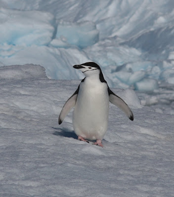
Chinstrap Penguin

Weddel Seals

Friday, 7 December 2007

About to start again

We finished our main piece of work - the Drake Passage CTD section - late on Tuesday. This allows an estimate to be made of the rate of flow of water around Antarctica, which is somewhere around 130 million cubic metres per second (over 600 times the flow of the Amazon). This is spread over a wide area, but it also organises itself into two main jets of flow, where the current can be well over 1 knot at the surface. At several stations the CTD package was very noticeably pulled towards aft (the ship faces the current when it stops), on the first one the winchman radioed the bridge to confirm we were actually stopped! We lower the CTD at 1m/s and the angle was sufficient for the horizontal component to create an odd feature in the acoustic current profiler data - though it took quite a bit of searching and thinking to work that out (and some geometry of the ship and instrument to confirm).

After the main section we have been going down the Antarctic Peninsula, past Deception Island (though unfortunately not in, would be hard to justify the time). Due to the delays at Stanley the stop at Damoy (an old base) was reduced to a morning and about 12 people went over to clear the place up - removing chemicals, old flares, two iced in skidoos and putting up health and safety notices. Didn't get asked to go and didn't want to take a place from someone else, after being extremely lucky to land on Crozet. The afternoon saw a call to Vernadsky, formerly the UK Faraday base, now Ukranian. Again, didn't get ashore for same reasons but that mostly saved me from being plied with vodka, so probably no bad thing. Scenery is spectacular, but conditions haven't been ideal for photography.

As of 8.30 this evening we start another CTD transect, to look at the possibility of warm and salty water from the deep ocean coming up a trench near Rothera and affecting the sea ice.

Photos to come

Monday, 3 December 2007

Humpbacks and other photos

On the first CTD station today (or at least the first I was awake for, work goes on through the night) there were at least 5 Humpback Whales at various distances from the ship. Viewing from the bridge with binoculars, got very good views of the closest (could see each bartnacle on the tail as it fluked) but no photos. However at the next station this was rectified as three came and hung around behind the ship and up each side for about 30 minutes, easily audible. Other wildlife has included a large rorqual blow (probably Fin Whale), a narrowly missed Minke Whale seen by someone else (did see the 'footprints' of its bubbles as it swam away), one Fur seal investigating the cable at the first deep station and lots of birds. Up to 7 species of albatross now, including a slightly out-of-range Sooty Albatross. More bird photos to come.


Humpback Whales

Sooty Albatross - slightly out of range

Black-browed Albatross

The CTD package - CTD stands for Conductivity, Temperature, Depth but the whole unit is 'the CTD'. Gets lowered to the bottom (well, 10 metres off if we get it right) at each station - about 4000m each way at 60metres/minute, plus stops to close the bottles to bring water back, so well about 3 hours in the water.

Sunday, 2 December 2007

Off and going

Things have now calmed down enough to send an update.

We got off and going Thursday afternoon and soon had the necessary boat drill - life jackets on and into the lifeboat. All slightly more real given that the Explorer is still marked on the navigation chart, in case she is drifting sub-surface. We then went straight into a shallow test CTD station, to give us and the kit a run through - all went fine.

CTD= Conductivity, Temperature, Depth - actually depth comes from pressure and latitude, then salinity comes from conductivity and temperature and density comes from temperature, salinity and pressure. 'The CTD' is used for the whole frame of sensors and bottles - there are 12 10litre bottles that we close on the way up - there is 2-way communication with the package down the wire. We need water to check the salinity measurements, so 10 litres is plenty, when there are others looking at oxygen, CO2, possibly trace gases such as CFCs (relatively new to the atmosphere so can use them to trace sinking water - timescale for the ocean is 1000-1500 years) and chlorophyll concenbtration then 10litres needs to be used sparingly, some other work needs 10 or more bottles from one depth.

After dinner Gerard and I checked out the ADCP (Acoustic Doppler Current Profiler - measures the water velocity from the doppler effect between 2 pings of sound, removing ship velocity using GPS) data - it had heading, pitch and roll, even if the display didn't. Early night before a 3am CTD the next morning - hadn't managed to activate the ADCPs mounted on the CTD frame (LADCP, L for Lower) on the shallow cast and it would have been too shallow to process the data anyway. They worked fine. Then went to the bridge for an hours birding before breakfast at 7.30. After that, started my actual 12 hour watch - lots of shallow CTD casts close together so no real break. By the end one of the LADCPs was playing up, but very little time between casts to investigate so we lost data for a few casts (not critical enough to hold the ship up). Still flaky, but we are getting there. Turned in at 10pm.

Up at 6am for an hour on the bridge with the binoculars, after checking status of LADCPs (at that stage they were worse, but we were beginning to work out why). Another 12 hour watch 8am-8pm but with deeper CTD casts further apart and we were more practised so generally much calmer. Managed to process some data. We had the deepest cast of the transect, 4700m, so the polystyrene cups came out (come back about 5cm high due to the high pressure). That was in a strong current so we had to drift about 2 miles to reduce the angle of the cable to the CTD package (cast took about 3.5 hours, surface current over 1 knot). Deployed an Argo float after the last cast at 9pm and then knocked off.

Much the same again today, another Argo float in, also pecked by the albatrosses to see if it was food. Argo floats drift at 2000m and take temperature and salinity measurements as they come to the surface every 10 days, feeds into oceanographic and meteorological real-time models, and other oceanographic analysis (such as about half of my thesis).

Quick note on the weather - we have incredibly good condition, sea state 2-4 (2 at the moment, no white wave caps) with about a 2 metre swell. Sun is out and it's quite pleasant in the sun, despite an air temperature of 5C (have been sampling in sweatshirt today, was t-shirt yesterday when water was a bit warmer at about 6C). Only thing that's moved because of the ship motion so far has been the soup. On that note, it's lunchtime.

Photos to come